Thursday 30 May 2013

The Beginings

Birth

In the second week of January in the year 1984, a child was born to Mr. Vitalis Oloo Ndir and Mrs. Veronica Nyakesa Oloo in a rural village in Siaya district (now Siaya county), western Kenya. Having been born in the morning, the boy child was named Omondi, loosely translated as "early riser" in the local Luo dialect. When I was 9, I was baptised at St. Michael's Sigomre Catholic Church and named Francis and thus henceforth my full name became FRANCIS OMONDI OLOO

Education

Having been born in the same year that the Government of Kenya introduced the 8-4-4 education system, I spent 8 years at Madungu Primary School where I sat the Kenya Certificate of Primary Education (KCPE) in the year 1997 after which I was admitted to Sawagongo High School in Siaya District.

I Joined Sawagongo High School on 25th February, 1998 and was in the school for the next four years. During my time in the school, I actively participated in drama and especially in the dramatized dance category where for a bigger part, I was the lead drummer for the dance troupe. I Sat the Kenya Certificate of Secondary Education (KCSE) in November, 2001 and scored 81 out of the possible 84 points.

Since I had performed better in Mathematics and Sciences, I had hoped to pursue a career in Electrical and Electronic Engineering however by a stroke of fate, I chose to pursue a career in Surveying and thus was admitted at the Department of Surveying at the University of Nairobi where I graduated with First Class honors in Bachelor of Science (Surveying) in October, 2008

From 01.03.2012 I was enrolled at the University of Salzburg, Austria to study for a Masters of Science degree course in Applied Geoinformatics. My studies in Austria were funded by the Austrian Agency for International Cooperation in Education and Research (OeAD). I intend to be done with my studies at the end of July, 2013.

On 01.07.2013 I received a Masters of Science degree in Applied Geoinformatics from the University of Salzburg. I passed with a distinction (Mit Auszeichnung Bestanden)


Work

From January, 2009. I was employed as a GIS Technician at the World Agroforestry Centre (ICRAF) my key role in this post involved GIS data capture and mapping.

In July 2010, I signed a new contract as a GIS Analyst and with this I was attached to two regional projects where my main roles were GIS training and mapping land health and land degradation in Ethiopia highlands and in the Lake Tanganyika Basin. I successfully executed my tasks and only resigned from the post in March, 2012 to pursue further studies. In the course of my work, I learnt quite a lot from my supervisors, Dr. Thomas Gumbricht and Mr. Meshack Nyabenge. Additionally, I developed great interest in the field of Geoinformatics and especially in system development, web-applications and applications of GIS and Remote Sensing technology in solving natural resource oriented problems. As part of my work, I was involved in training rural stakeholders on how to use basic GIS skills in making decisions on natural resource management.

Training stakeholders in Uvira, Democratic Republic of Congo

Hobies

When not involved in academic and professional activities, I spend my time in the following activities:
  • Playing soccer
  • Reading literature and world news
  • Blogging
  • Listening to music
  • Exploring nature


Coming to Salzburg

My Journey to the Centre for Geoinformatics (ZGIS) at the University of Salzburg started when I met Dr. Luke Olang' who is a professional in Hydrology and who had himself studied in Austria under the OeAD scholarship. Through his networks which he developed while pursuing his doctorate studies at BOKU, the University of Natural Resources and Life Sciences in Vienna, he introduced me to OeAD scholarship program and also communicated with Professor Josef Strobl, the Director at ZGIS about my zeal to further my studies in Geoinformatics at the University.

With the help of Dr. Olang', Prof. Strobl and Madam Elke of the OeAD office, I was successfully awarded a scholarship to study at the ZGIS and I earnestly enrolled and began my course work on 1st of March, 2012.

I Am sincerely grateful for the opportunity and privilege accorded to me by OeAD to be able to pursue my studies in Austria and particularly at the Centre for Geoinformatics, University of Salzburg

The journey continues

Wednesday 29 May 2013

Thesis: Assessment of photovoltaic solar energy potential in Kenya

Abstract

Accessibility to affordable and sustainable energy resources could have a major impact to the economies of developing countries and in the livelihoods of the citizens of those nations. Solar energy is one of the readily available renewable energy resources and especially to the countries which are located within the tropics. Kenya is one of the countries in the tropical region and receives an average of 6.5 sunshine hours in a single day throughout the year. The main reason for the slow adoption of solar energy resources in Kenya has been the general lack of information of the spatial variability of the characteristics of solar energy potential within the country. The second reason has been due to the high cost of solar energy technology and the lack of a comprehensive legal framework in support of investment in solar energy sector. 

The aim of this work was to assess the potential of solar energy in Kenya and particularly the potential of photovoltaic solar energy generation. The main factors that have an influence on the incident solar radiation that were considered in the study were atmospheric transmissivity and the nature of topography. The influence of atmospheric transmissivity was factored in by modelling monthly transmissivity factors from a combination of cloud cover, diffuse ratios and a correction for the influence of elevation on atmospheric transmissivity. The contribution of topography on the other hand was factored into the model by applying hemispherical viewshed analysis to determine the amount of incident global radiation on the surface based on the orientation of the terrain. This was implemented through the Solar Analyst Tool in ArcGIS 10. In order to integrate the different spatial datasets in the model, GIS methods and tools were used.

The result of the analysis showed that on average, approximately 95% of the land in Kenya has the potential of receiving approximately 5kWh/m2/day throughout the year. From the analysis of the monthly data, the maps of monthly solar energy potential in the period between April and September had relatively large areas of land characterised as high potential areas when compared to the other months. This task successfully attempted to assess and to document the spatial variability in the characteristics of solar energy potential in Kenya.

Key words: energy, solar energy, renewable energy, radiation, GIS

Note: The online map of monthly and annual solar energy potential in Kenya can be found here.

Thursday 18 April 2013

Geobrowsers: Embedding a web map onto a blog

As part of Applications development for Geo-browsers, we were introduced to the concepts of web mapping. The first of which was the use of simple HTML tags to embed web maps onto websites and blog sites.The figure below shows an example of Google map as embedded on the blog. The basic tools from Google Maps API including zooming (in and out) and navigation were enabled


Wednesday 20 February 2013

CO2Print: Mobile Carbon Footprint Application

This presentation was created for a concept on mobile carbon footprint mapping. The task was carried out as one of the requirements for the "Location Based Services study". course


Sunday 17 February 2013

GIS Project: Comparative analysis of solar energy potential in Kenya and Pakistan

The power of GIS is in the ability to combine different layers in order to create new insight about a phenomenon of interest. In this exercise, four main GIS layers were combined to map the potential of solar energy generation in Kenya and Pakistan. The four main layers were global solar radiation, cloud cover, land cover and the euclidean distance (from major towns and transport infrastructure). The choice of Kenya and Pakistan in this study was based on the fact that the two countries are located in different climatic zones with Kenya in the equatorial zone and Pakistan in the temperate zone. Additionally, my partner for the project was from Pakistan while I am originally from Kenya.

The data for this project were mainly from publicly available sources especially in the internet. ArcGIS and ENVI softwares were the main softwares used in the project. The figure below shows the methodology adopted for the project.
Project work for solar energy potential mapping

In the methodology above, Solar analyst in ArcGIS was used to carry out solar analysis on elevation layers for both countries. Secondly, distance analyst was used to create euclidean distance layers with reference to the major towns and roads, a representative euclidean layer was then generated by computing the average of the two layers. Thirdly the land cover layers obtained from different sources for the two different countries were rasterized to allow them to be combined with the other layers. Finally, NOAA-AVHRR CLASS imagery for both countries were analyzed to come up with a representative cloud cover layers for both countries.

With all the four layers ready, a weighted overlay procedure was carried out to combine the layers. Finally, map algebra was used to subtract water bodies and gazetted (protected areas) from the potential sites. The maps below show the map of potential sites in Kenya and Pakistan respectively.

Solar energy potential map of Kenya

Solar energy potential map of Pakistan

As a final step, zonal statistics was used to determine the administrative units with the highest potential in both countries. From the study, it was observed that due to the location of Kenya along the equator and also in view of the favorable terrain in close proximity to the equator, a relatively large portion of Kenya was classified within the very high or high potential areas as opposed to Pakistan.

The presentation that was made as part of this study is embedded below

References
  • Fu, P. & Rich, P.M., 2000. The solar analyst 1.0 manual. Helios Environmental Modeling Institute (HEMI), USA. 
  • Fu, Q., 1996. RADIATION ( SOLAR ). , (1981), pp.1859–1863. 
  • Hammer, A. et al., 2003. Solar energy assessment using remote sensing technologies. Remote Sensing of Environment, 86(3), pp.423–432. Available at: http://linkinghub.elsevier.com/retrieve/pii/S003442570300083X [Accessed November 1, 2012]. 

Geo-visualization by Cartograms

Cartograms are types of maps in which  statistical information is represented relative to the area of the spatial unit to which the statistical information belongs. Cartograms can be used to create more insight on the spatial distribution of a particular variable with respect to the different spatial areas under consideration.

During the Cartography and Geo-visualization course,  cartograms were used to represent various variables in Kenya. For instance, the maps below show the spatial distribution of poverty in Kenya and accessibility to electricity within the country.
Households with access to electricity in Kenya per county

Cartogram of poverty represented against the areas of counties


Thursday 24 January 2013

Cartographic representation of the potential of solar energy in Kenya

This presentation was made as part of the Cartography and Geovisualization course at the University of Salzburg. The task was carried out together with two other student colleagues; Mrs. Romana Basir and Mr. Simon Haufe


Thursday 20 December 2012

GIScience: Is it developing into a scientific discipline?

 Introduction

Geographic information (GI) is the information derived from facts about geographic features and phenomenon in the vicinity of the earth’s surface (M. Goodchild et al. 1998). Geographic information science (GIScience) has been defined as a basic research field whose aim is to define (or redefine) geographic concepts in the context of geographic information systems (Mark 2003). 

There have been three main motivations to the development of the field of GIScience (M. Goodchild et al. 1998), these are i) Scientific motivation which promotes the development of GIScience as a field to facilitate discovery of geographic truths in areas where they have not been found, to contribute to conceptualization, tools and methods with which geographic phenomena can be handled and to contribute to the general infrastructure of science given that different disciplines have the earth’s surface as their area of domain. ii) Technological motivation which has directly and indirectly influenced GIScience to take advantage of the development of technology in ensuring logical and consistent representation of GI. ii) Societal motivation to formalize human spatial thinking capabilities into geographic knowledge and to address the impact of GI technology in societal issues including democracy and privacy.

Development of the field


While writing a motivation to advocate for a centre to be funded by the National Science Foundation (Abler 1987) suggested potential areas of research for a Nation Centre for Geographic Information Analysis. Goodchild refined and expanded the topics and coined the term “geographic information science” (M. F. Goodchild 1992). With the formation of University Consortium for Geographic Information Science (UCGIS), more inclusive and formal definition and periodical research priorities were formed and (Mark 2003) reviewed different literature and came up with a comprehensive definition of the field.


Components of GIScience


In most of the discussions about the research topics to include in GIScience, three critical areas have emerged around which such topics evolve, these are; people, society and computer (technology). The critical questions have been: a) how do people conceptualize about their geographic environments? b) What societal factors influence (or hinder) the adoption of GI technology and how does such technology impact on the society? c) How can we take advantage to formalize conceptualization about geographic phenomena and improve functionality of GI tools for GI analysis and representation?(M. F. Goodchild 2010). With these questions, GIScience research has been formulated to answer scientific questions in different subtopics including: spatial cognition, user interface design, public participation GIS, spatial uncertainty, spatial analysis, privacy, spatial data infrastructure, algorithm and data modelling among others.

At the same time clear criteria have been formulated to draw the limits of GIScience research, these include ; that such research should be in areas of GI that have not yet been discovered; that the research should be generic and not limited to the context of enquiry ; that the nature of the research should be hard enough and should be recognized as such by scientists in other disciplines (M. F. Goodchild 2010).

Laws of GIScience

In the development of the discipline, a number of laws have emerged (or have become clearer), these include i) Tobler’s First Law of geography which has now found a home in GIScience with many applications including spatial autocorrelation, interpolation, resampling, contour mapping among others. ii) The principle of spatial heterogeneity which implies that due to the structural difference of locations, the results of any spatial analysis depends on the bounds under consideration. iii) Fractal principle which implies that geographic phenomena reveal additional information the closer one looks at it. iv) The principle of spatial uncertainty which acknowledges that geographic world is complex and every representation of (abstraction from) geographic phenomena contains an uncertainty (Anselin 1989) 


Impacts of GIScience discipline


GIScience has made significant inroads in the world of science through the variety of high impact publications that have been cited in different scientific disciplines. This has mainly been through the emergence and renaming of journals to publish scientific articles in the discipline of GIScience. Additionally high impact annual and periodical conferences have been organized where GIScience researchers get an opportunity to share their findings with scientists from other disciplines. Figure 1 shows the annual variation in number of articles in the field of GIScience as searched from Thompson Reuters Web of Knowledge. The different search terms used were “Geographical Information Science”, “Geographic Information Science” and “GIScience”
 
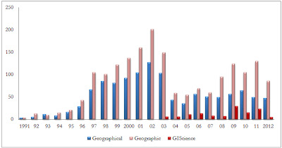
Figure 1: Articles in the field of GIScience as searched from Thompson Reuters Web of Knowledge

In figure 2, the annual variation (from 1992 to 2011) of the number of publications and citations of articles searched with the keywords “Geographic Information Science” on Microsoft academic search website are presented
 
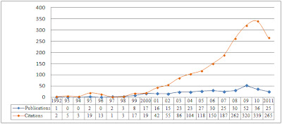
Figure 2: Annual variations of publications and citations of GIScience related articles according to Microsoft Academic Research tool


The other evident impacts that have emerged from GIScience have been the formal institutional frameworks to coordinate and formalize national, regional and continental research and education in GIScience. Such efforts include UCGIS, AGILE and UNIGIS. In the same breadth a number of post graduate course are offered throughout the world in GIScience and related fields.

Finally, because of research in GIScience, GI and GI technology have become very significant in a number of areas of application including policy making and governance, medical research, disaster management, urban and regional planning, climate change prediction and mitigation, agriculture, forest management, mining and exploration among many other applications.


Conclusion


In the short period of the existence of GIScience as a field, it has made significant progress and continues to develop into a fully fledged scientific discipline. This progress has been made possible by the clarity in definition of the field and the domain of operation of the field. As a result, different laws or principles have emerged which continue informing decisions that have to do with geographic phenomena. Additional, there are now institutional frameworks that will further enhance the structural development of the discipline. Similarly the proliferation of scientific journals to document research findings has created a demand for GI knowledge that can only be satisfied by proper research in GIScience. This coupled with emerging study curricula in GIScience throughout the world and broad areas of application will forever cement the position of GIScience as a scientific discipline.

The presentation that was made on this topic is embedded herein:
 

The full paper can be found in the link below:


References

Abler, R.F., 1987. The National Science Foundation National Center for Geographic Information and Analysis. International journal of geographical information systems, 1(4), pp.303–326. Available at: http://www.tandfonline.com/doi/abs/10.1080/02693798708927819.
Anselin, L., 1989. What is special about spatial data?: alternative perspectives on spatial data analysis. In Spring 1989 Symposium on Spatial Statistics, Past, Present and Future, Department of Geography, Syracuse University. Santa Barbara, CA: National Center for Geographic Information and Analysis.
Goodchild, M., Egenhofer, M. & Kemp, K., 1998. Whither Geographic Information Science? The Varenius Project A Special Issue of the International Journal of Geographical Information Science Introduction . structure, (February 1997), pp.1–102. Available at:           http://cfc.umt.edu/giscertificate/Documents/Goodchild1.pdf [Accessed December 1, 2012].
Goodchild, M.F., 1992. Geographic Information Science. International Journal of Geographic Information Systems, 6(1), pp.31–45.
Goodchild, M.F., 2010. Twenty years of progress: GIScience in 2010. Journal of Spatial Information Science, 1(1), pp.3–20. Available at: http://josis.org/index.php/josis/article/view/32 [Accessed November 24, 2012].
Mark, D.M., 2003. Geographic Information Science: Defining the Field M. Duckham, M. F. Goodchild, & M. F. Worboys, eds. Science, pp.1–15. Available at:           http://scholar.google.com/scholar?hl=en&btnG=Search&q=intitle:Geographic+Information+Science+:+Defining+the+Field#0.