This presentation was made as part of the Cartography and Geovisualization course at the University of Salzburg. The task was carried out together with two other student colleagues; Mrs. Romana Basir and Mr. Simon Haufe
Thursday, 24 January 2013

Thursday, 20 December 2012
GIScience: Is it developing into a scientific discipline?
Introduction
Geographic information (GI) is the information derived
from facts about geographic features and phenomenon in the vicinity of the
earth’s surface (M. Goodchild et al. 1998). Geographic
information science (GIScience) has been defined as a basic research field whose
aim is to define (or redefine) geographic concepts in the context of geographic
information systems (Mark 2003).
There have been three main motivations to the
development of the field of GIScience (M. Goodchild et al. 1998), these are i)
Scientific motivation which promotes the development of GIScience as a field to
facilitate discovery of geographic truths in areas where they have not been
found, to contribute to conceptualization, tools and methods with which geographic
phenomena can be handled and to contribute to the general infrastructure of
science given that different disciplines have the earth’s surface as their area
of domain. ii) Technological motivation which has directly and indirectly
influenced GIScience to take advantage of the development of technology in
ensuring logical and consistent representation of GI. ii) Societal motivation
to formalize human spatial thinking capabilities into geographic knowledge and
to address the impact of GI technology in societal issues including democracy
and privacy.
Development of the field
While writing a motivation to advocate for a centre to
be funded by the National Science Foundation (Abler 1987) suggested
potential areas of research for a Nation Centre for Geographic Information
Analysis. Goodchild refined and expanded the topics and coined the term
“geographic information science” (M. F. Goodchild 1992). With the
formation of University Consortium for Geographic Information Science (UCGIS),
more inclusive and formal definition and periodical research priorities were formed
and (Mark 2003) reviewed
different literature and came up with a comprehensive definition of the field.
Components of GIScience
In most of the discussions about the research topics
to include in GIScience, three critical areas have emerged around which such
topics evolve, these are; people, society and computer (technology). The
critical questions have been: a) how do people conceptualize about their
geographic environments? b) What societal factors influence (or hinder) the
adoption of GI technology and how does such technology impact on the society?
c) How can we take advantage to formalize conceptualization about geographic
phenomena and improve functionality of GI tools for GI analysis and
representation?(M. F. Goodchild 2010). With these
questions, GIScience research has been formulated to answer scientific questions
in different subtopics including: spatial cognition, user interface design,
public participation GIS, spatial uncertainty, spatial analysis, privacy,
spatial data infrastructure, algorithm and data modelling among others.
At the same time clear criteria have been formulated
to draw the limits of GIScience research, these include ; that such research
should be in areas of GI that have not yet been discovered; that the research
should be generic and not limited to the context of enquiry ; that the nature
of the research should be hard enough and should be recognized as such by
scientists in other disciplines (M. F. Goodchild 2010).
Laws of GIScience
In the development of the discipline, a number of laws
have emerged (or have become clearer), these include i) Tobler’s First Law of geography
which has now found a home in GIScience with many applications including
spatial autocorrelation, interpolation, resampling, contour mapping among
others. ii) The principle of spatial heterogeneity which implies that due to
the structural difference of locations, the results of any spatial analysis
depends on the bounds under consideration. iii) Fractal principle which implies
that geographic phenomena reveal additional information the closer one looks at
it. iv) The principle of spatial uncertainty which acknowledges that geographic
world is complex and every representation of (abstraction from) geographic
phenomena contains an uncertainty (Anselin 1989)
Impacts of GIScience discipline
GIScience has made significant inroads in the world of
science through the variety of high impact publications that have been cited in
different scientific disciplines. This has mainly been through the emergence
and renaming of journals to publish scientific articles in the discipline of
GIScience. Additionally high impact annual and periodical conferences have been
organized where GIScience researchers get an opportunity to share their
findings with scientists from other disciplines. Figure 1 shows the annual
variation in number of articles in the field of GIScience as searched from
Thompson Reuters Web of Knowledge. The different search terms used were
“Geographical Information Science”, “Geographic Information Science” and
“GIScience”
 |
| Figure 1: Articles in the field of GIScience as searched from Thompson Reuters Web of Knowledge |
In figure 2, the annual variation (from 1992 to 2011) of the number of publications and citations of articles searched with the keywords “Geographic Information Science” on Microsoft academic search website are presented
 |
| Figure 2: Annual variations of publications and citations of GIScience related articles according to Microsoft Academic Research tool |
The other evident impacts that have emerged from GIScience have been the formal institutional frameworks to coordinate and formalize national, regional and continental research and education in GIScience. Such efforts include UCGIS, AGILE and UNIGIS. In the same breadth a number of post graduate course are offered throughout the world in GIScience and related fields.
Finally, because of research in GIScience, GI and GI
technology have become very significant in a number of areas of application
including policy making and governance, medical research, disaster management,
urban and regional planning, climate change prediction and mitigation, agriculture,
forest management, mining and exploration among many other applications.
Conclusion
In the short period of the existence of GIScience as a field, it has made significant progress and continues to develop into a fully fledged scientific discipline. This progress has been made possible by the clarity in definition of the field and the domain of operation of the field. As a result, different laws or principles have emerged which continue informing decisions that have to do with geographic phenomena. Additional, there are now institutional frameworks that will further enhance the structural development of the discipline. Similarly the proliferation of scientific journals to document research findings has created a demand for GI knowledge that can only be satisfied by proper research in GIScience. This coupled with emerging study curricula in GIScience throughout the world and broad areas of application will forever cement the position of GIScience as a scientific discipline.
The presentation that was made on this topic is embedded herein:
The full paper can be found in the link below:
References
Abler, R.F., 1987. The National
Science Foundation National Center for Geographic Information and Analysis. International
journal of geographical information systems, 1(4), pp.303–326. Available
at: http://www.tandfonline.com/doi/abs/10.1080/02693798708927819.
Anselin, L., 1989. What is special
about spatial data?: alternative perspectives on spatial data analysis. In Spring
1989 Symposium on Spatial Statistics, Past, Present and Future, Department of
Geography, Syracuse University. Santa Barbara, CA: National Center for
Geographic Information and Analysis.
Goodchild, M., Egenhofer, M. &
Kemp, K., 1998. Whither Geographic Information Science? The Varenius Project A
Special Issue of the International Journal of Geographical Information Science
Introduction . structure, (February 1997), pp.1–102. Available at:
http://cfc.umt.edu/giscertificate/Documents/Goodchild1.pdf [Accessed December
1, 2012].
Goodchild, M.F., 1992. Geographic
Information Science. International Journal of Geographic Information Systems,
6(1), pp.31–45.
Goodchild, M.F., 2010. Twenty years
of progress: GIScience in 2010. Journal of Spatial Information Science,
1(1), pp.3–20. Available at: http://josis.org/index.php/josis/article/view/32
[Accessed November 24, 2012].
Mark, D.M., 2003. Geographic
Information Science :
Defining the Field M. Duckham, M. F. Goodchild, & M. F. Worboys, eds. Science,
pp.1–15. Available at:
http://scholar.google.com/scholar?hl=en&btnG=Search&q=intitle:Geographic+Information+Science+:+Defining+the+Field#0.
Friday, 23 November 2012
Scripting languages: Python, Php and Perl
This presentation was made as part of student work in "Fundamentals of Software Engineering" course at the University of Salzburg. The presentation was made with two other students; Patrick Havel and Michel Schwandner.
Thursday, 11 October 2012
Selected Modules in Winter 2012/13 Semester
The following courses were pursued in the winter semester of the academic year 2012/ 2013
• GIS Project
• GIScience: Theories and Concepts
• Cartography and Geovisualization
• Ontologies and Semantics (Harmonizing Geospatial Information)
• Design of Geospatial Data Models
• Distributed GI Architectures
• Fundamentals and Concepts of Software Engineering
• Geosimulation
• Location Based Services
• Softwaredesign for Geoinformatics
• Global Problems and Perspectives
• Spatial Analysis
Rectangular Buffer Tools
Apart from using the available GIS tools in readily available commercial and open source software. The course in Msc Applied Geoinformatics provided opportunities for me to apply established GIScience concepts in creating usable GIS tools. One of such tools was the rectangular buffer script tool created for the ArcGIS 10 software. Using python language, the tool was designed to accept user input including point features and the buffer distance and then computing rectangular buffers around the point features.
Additionally, adequate documentation was provided to help any users of such tools. I have been able to develop small scripts to carry out minor repetitive tasks in ArcGIS 10 including scripts to carry out spline interpolation on point features with many fields in the attribute table.

International Schools, Star Hotels and First Class Hospitals in Nairobi
In this class project, OpenLayers javascript library was used to create a web map application of international schools, top class hotels and international standard hospitals in Nairobi Kenya, this was the key deliverable for the Web Mapping.
In the project, Google Maps, Google hybrid, Google terrain and Open Street Maps were used as base layers while international schools, top star hotels and international standard hospitals were added as over-layers. The overlays were introduced as vector layers with clickable popups as can be seen in the image below.

Monday, 1 October 2012
Field work:Sasumua Catchment, Kenya
Between July 2012 and October 2012, I had the privilege of carrying out a field work in Sasumua Catchment Kenya. The original intention was to collect data that I would use for my final thesis. The full report is embedded below:
Wednesday, 5 September 2012
Water Evaluation and Planning (WEAP) tool for water resource management
This presentation was made as a seminar presentation which was part of the "Analysis and Modelling" seminar course for the Msc Applied GeoInformatics course at the University of Salzburg
The full report for the student task can be found in the link below:
Friday, 31 August 2012
Europe talks about money
In this class project, a database of twitter
data for the continental Europe was analysed with the intention of finding out
whether the data could be used extract all the money related talk and whether
this information could then be used to make financial decisions. From 14
million tweet streams, slightly more than 200 thousand tweets referred to money
in six different languages; English, German, French, Italian, Spanish, Dutch
and Greek. Seven countries in Europe
were used for the study, these were United Kingdom (and Northern Ireland),
France, Germany, Italy, Netherlands, Spain and Greece. Using GeoTools, Processing
(Fry and Reas, 2010) and MapThing (Reades, 2012) libraries in Java, the money
related tweets were dynamically mapped for the 29 days in February 2012.
According to the study it was observed that most money related talk takes place
in major cities with the most significant city being London.
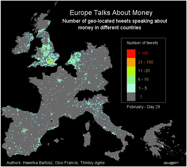 |
| Screen shot of money related tweets for the 29th February, 2012 |
Acknowledgements
I acknowledge the inputs from my colleagues Bartosz Hawelka and Jigme Thinley
Further details on the entire scope of the project can be found on http://lbswinners.blogspot.co.at/
References
- Fry, B., & Reas, C. (2010). Processing. Retrieved July 10, 2012, from Processing: http://processing.org/reference/frameRate_.html
- Reades, J. (2012). Processing Library MapThing. Retrieved July 10, 2012, from Processing Library MapThing: http://www.reades.com/MapThing/
Summer Semester 2012
Being my first semester at the university, I cautiously selected courses, the list of which is outlined below
- Geo-Applications: Developing of Geoprocessing Applications using Python and ArcGIS
- Advances Remote Sensing
- Object Based Image Analysis
- Geostatistics and Environmental Modeling
- System Development in Geoinformatics
- Spatial Data Capture
- Geosimulation
- Analysis and Modeling
- Terrain Analysis and Runoff Modeling
- Web Mapping and Online Application
- Location Based Services/ Collective Sensing
- GIS Tools for Landscape Analysis and Modeling
- ePortfolio
Subscribe to:
Posts (Atom)